Mapping a Community: Hershey’s Sanborn Maps
Hershey Community Archives has a wonderful collection of maps and plans that document the construction of individual buildings and the development of the town and its infrastructure. While most of the maps and plans in the collection are original prints created by Hershey employees or companies hired by Hershey, the collection also includes maps created by third-party organizations for a variety of purposes. Some of those commercial maps in the collection are Sanborn insurance maps.
The Sanborn Company began making fire insurance maps in 1867. The company was founded by Daniel Alfred Sanborn, a surveyor from Somerville, Massachusetts. The Sanborn Map Company created maps for assessing fire insurance liability in urbanized areas in the United States. The maps include detailed information regarding town and building information in approximately 12,000 U.S. towns and cities from 1867 to 1970 for fire insurance assessment in the U.S. and within several decades became the largest and most successful American map company. The Sanborn Company sent out legions of surveyors to record the building footprints and relevant details about these buildings in all major urbanized areas regarding their fire liability. It was because of these details and the accuracy of the Sanborn maps, coupled with the Sanborn Company’s standardized symbolization and aesthetic appeal that made the Sanborn Company so successful and their maps so widely utilized.
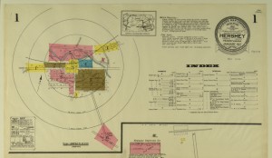
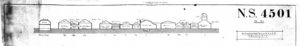
Hershey’s Sanborn maps are large-scale lithographed street plans at a scale of 100 feet to one inch (1:300) on 21 inch by 25 inch sheets of paper. The volumes contain an enormous amount of information. They are organized as follows: a decorative title page, an index of streets and addresses, and a master index indicating the entirety of the mapped area and the sheet numbers for each large-scale map (usually depicting four to six blocks) and general information such as population, economy and prevailing wind direction. The maps include outlines of each building and outbuilding, the location of windows and doors, street names, street and sidewalk widths, property boundaries, fire walls, natural features (rivers, canals, etc), railroad corridors, building use (sometimes even particular room uses), house and block number, as well as the composition of building materials including the framing, flooring, and roofing materials, the strength of the local fire department, indications of sprinkler systems, locations of fire hydrants, location of water and gas mains and even the names of most public buildings, churches and companies.
Hershey Community Archives has 6 Sanborn insurance maps in its collection that document different parts of Hershey. Recently the Library of Congress digitized and posted on its American Memory website Hershey’s first Sanborn map which was published in 1915. The map consists of 4 pages and documents the town as it existed in 1915. It is a wonderful snapshot of the community that had recently celebrated its 10th anniversary in 1913.
For more information about the Archives’ map collection or its other holdings, please contact the Archives.
Gallery
Click image to view larger